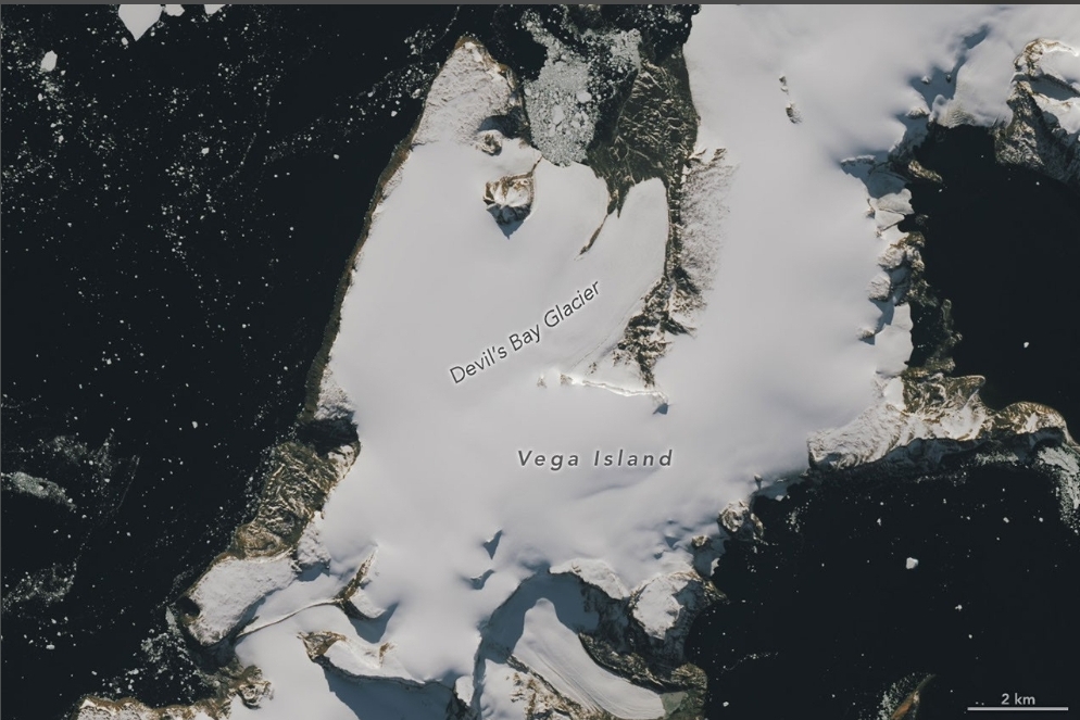
NASA’s Earth Observatory published Landsat 9 images on Oct. 30 showing Vega Island in Antarctica, an island whose features resemble a grinning skull, after a warm winter stripped snow from large areas of its ice, NASA said.
The Vega Island skull sits in the Weddell Sea east of the Antarctic Peninsula. Two images 567 days apart show one season of loss. The longer evidence is the glacier monitoring that began in the 1998-1999 summer, which has measured an overall decline in mass.
What the Vega Island Skull Looks Like
A nunatak, a rocky peak that pokes through the ice, forms the eye socket, NASA said. A lateral moraine, the ridge of debris along the side of a glacier, forms the mouth, and Bahía del Diablo, also called Devil’s Bay Glacier, forms the jawbone. The face appears to look toward nearby Devil Island.
Landsat 9’s Operational Land Imager took both pictures. The first, on March 22, 2025, shows snow covering the ice at the start of the austral autumn. The second, on Oct. 10, 2026, shows snow gone from large areas and darker ice exposed. Clouds hid the island in March 2026. The gap between the two images is 567 days, a calculation from NASA’s dates.
Why the Antarctic Ice Is Darker This Spring
Above-average temperatures in the winter of 2026, especially in June, help explain the extensive bare ice, NASA said. Bare ice is darker than snow and absorbs more solar energy, so melting is expected to speed up as days warm.
Mauri Pelto, a glaciologist at Nichols College, said, “The winter season was no treat for these glaciers.” He said even a thin cover of new snow from a spring storm would help in the short run, and that continued melt could gradually reshape the skull’s jawline and eye socket.
How Long Scientists Have Watched Vega Island
A 1982 study used early Landsat data, aerial photography and topographic maps to describe four ice caps and 29 glaciers on Vega Island. Devil’s Bay Glacier has been monitored in detail since the 1998-1999 summer, and those measurements show an overall loss of mass, NASA said. Satellite images show other glaciers on the island have also lost ice and exposed more bedrock. Two images cannot establish a trend, and one warm winter does not either. Pelto’s point is narrower: a snow cover protects the ice, and this year less of it stayed.
The Expedition That Ended Beside the Skull
The area has a human history. The Swedish Antarctic Expedition of 1901 to 1903 lost its ship to pack ice and split into three groups that wintered in different places. In the spring of 1903 two groups reunited at Cape Well-met, near the skull’s forehead, and an Argentinean expedition later rescued the survivors, NASA said.