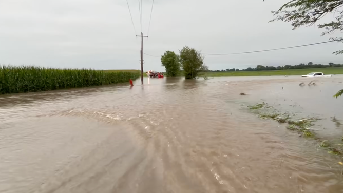
A stalled weather system pulling tropical moisture triggered days of repeated flash flooding across the Midwest, Plains and Ohio Valley through the weekend of Sept. 20-21, with some Indiana communities recording more than 8 inches of rain in less than a week.
Where the Flooding Hit Hardest
The National Weather Service issued flash-flood warnings across Ohio, Indiana, Pennsylvania and
West Virginia as the system stalled over the region starting around Sept. 16. Bluffton and Linn Grove, Indiana, recorded more than 8.5 inches of rain since the preceding Wednesday, prompting emergency sandbagging efforts, according to Fox Weather. Des Moines and Omaha logged more than 3 inches of rain since the start of the week, while a single National Weather Service warning issued Sept. 20 for Charleston, West Virginia’s coverage area cited 2.5 to 3.5 inches falling in one morning over the southeastern Ohio communities of Wellston, McArthur, Hamden, Allensville, Byer and Eagle Mills.
The NOAA Storm Prediction Center placed eastern Iowa, northern Illinois and northwestern Indiana under a Level 3-of-4 flash-flood risk, one of the higher categorical warnings the agency issues, and specifically flagged “locally considerable urban flooding” potential for the Chicago metro area. No deaths or injuries had been reported in connection with the system as of this writing.
Why a Stalled Front Produces This Much Rain
The flooding traces to a specific meteorological setup: rather than a storm system moving through and clearing the region within a day, a frontal boundary stalled in place and continued pulling tropical moisture northward for the better part of a week, allowing the same general area to receive repeated rounds of heavy rain rather than a single pass.
That pattern explains why Bluffton’s 8.5-inch total accumulated over roughly six days rather than from one dramatic storm, and why the risk area shifted somewhat day to day even as the overall system remained largely fixed in place over the Ohio Valley and eastern Midwest.
The Level 3 Risk Category, Explained
NOAA’s Storm Prediction Center flash-flood risk scale runs from a Level 1 marginal risk to a Level 4 high risk, with Level 3 reserved for situations where forecasters have high confidence that a significant portion of the outlook area will see flooding capable of affecting roads, property and, in the worst cases, lives.
Placing eastern Iowa, northern Illinois and northwestern Indiana at Level 3 this weekend put a stretch of the country’s most densely populated Midwest corridor, including the Chicago metro area, in the agency’s second-highest flood-risk tier, a designation that is not issued lightly given how frequently the region sees routine summer thunderstorms that do not rise to that level.
Why Flash Floods Outpace River Flooding
Flash flooding differs from the slower, more predictable river flooding that follows days of steady rain, because it develops when rainfall arrives faster than the ground, storm drains and small streams can absorb or carry it away, often within hours rather than days. Urban areas like Chicago are especially vulnerable to this kind of rapid-onset flooding because pavement and other impervious surfaces prevent water from soaking into the ground the way it would in rural terrain, concentrating runoff into streets and low-lying underpasses faster than storm sewers can handle it.
That is why the Storm Prediction Center’s warning specifically flagged “locally considerable urban flooding” for the Chicago area rather than describing a slower-developing river-flood threat, even though the same stalled system was also raising river levels across the wider region as days of rain accumulated upstream.
The Scale of the Area Under Threat
The Level 3 risk zone covering eastern Iowa, northern Illinois and northwestern Indiana encompasses a stretch of the Midwest that includes the Chicago metropolitan area’s roughly 9.5 million residents alongside the smaller cities and rural farmland that make up the rest of the outlook area, meaning the storm system’s reach extended well beyond the specific towns, like Bluffton and Linn Grove, that recorded the heaviest individual rainfall totals. Farther west, Des Moines and Omaha’s more than 3 inches of rain since the start of the week added a second, separate cluster of heavy rainfall outside the Level 3 zone entirely, illustrating how the same stalled frontal system produced significant flooding risk across a footprint spanning multiple states rather than concentrating its impact in one location.
What Happens Next
Storms were forecast to continue into the start of the week as the stalled system gradually shifted, meaning rivers and low-lying or urban areas remained at elevated risk of further flooding beyond the weekend. The National Weather Service continued issuing rolling flash-flood warnings as new rounds of storms developed, and local officials in the hardest-hit Indiana communities were continuing sandbagging and monitoring efforts as of this weekend’s reporting.
Rivers that received the heaviest upstream rainfall, particularly in the Ohio Valley communities that saw multiple consecutive days of storms, were expected to continue rising for several days after the rain itself tapered off, meaning the flood threat in those areas was likely to outlast the storms that caused it.